The main goals of Aqua Science studies are to view the water cycle system as a field of interaction among the geosphere, anthroposphere, and biosphere and to carry out the following three approaches.
- To dynamically elucidate the present balance and historical changes of the focal point in the water cycle system under the actual conditions of each region based on data obtained from the geosphere, anthroposphere, and biosphere.
- To propose a vision of the future of the region and certain routes to that vision based on the research results obtained.
- To establish a reciprocal relationship between academia and the field to achieve a sustainable water cycle system in cooperation with stakeholders.
To achieve these three goals, this project involved the following research groups:
(1) The general research group
(2) Four planned research groups that included A. Geosphere (A01), B. Anthroposphere (B02, B03), and C. Biosphere (C01)
(3) A cross-academic team
(4) Publicly-offered research groups
(2) The research teams will be organized into four planned research groups based on three research items targeting the geosphere (A), anthroposphere (B), and biosphere (C). While the geosphere (A) and biosphere (C) are assigned one research group, two research groups will be established for research examining the anthroposphere (B). This is due to the observation that anthropospheric activities significantly impact the current state of the water cycle system, and it is necessary to analyze these activities from multiple perspectives.
To promote the field while maintaining organic coordination among the research groups, the research period was divided into two phases that included the first half (from the first to the third year) and the second half (from the fourth to the final year). In each phase, the roles of each research group and the coordination methods among the groups will be reconfigured. In the first half of the project, each planned research group will dynamically capture the “fluctuations” in the water cycle system from the past to the present and clarify how the equilibrium in the system has evolved. During this process, the datasets obtained from each sphere will be utilized reciprocally. For example, annual rings of wood excavated at archaeological sites, past newspaper articles, and folklore information will be provided to the planned research A01 in an attempt to improve the accuracy of the simulation, and concurrently, the simulation data will be utilized in the humanities as well as for ecological studies. Furthermore, based on microscale findings from the humanities and ecology, we propose parameters and datasets that need to be focused on by other planned research groups and thus promote joint research in collaboration with other groups. Each planned research group will be led by a representative, and three subthemes related to the overall theme will be established and structured, each with a subthematic leader.
In the latter phase of the project, when mutual collaboration among the research groups becomes necessary, a cross-academic team (consisting mainly of the area representative, the planned research group representative, and the sub-theme leaders) will be organized beyond the existing framework of the research plans. The cross-academic team will play a central role in the creation of Aqua Science studies, including scenario development for the realization of a sustainable water cycle system and its social implementation, based on the research results obtained by each planned research group.
In this research area, several joint fields will be established in which multiple planned research groups will work together to conduct surveys, research, and social implementation.
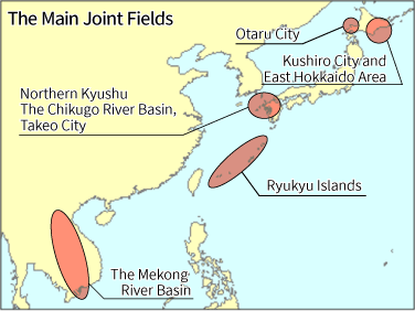
The main joint fields are as follows:
- Northern Kyushu (particularly Takeo City, Saga Prefecture)
- Kushiro City and the East Hokkaido area
- Otaru
- The Ryukyu Islands
- The Mekong River basin.
The reasons for establishing the joint field are as follows.
- The Chikugo River Basin, the largest river in Kyushu, was included. It is suitable for research examining water cycle systems from various perspectives, including river traffic, estuary development, the use of tidal flats, and frequent heavy rainfall disasters.
- The Kushiro Marshland, the largest RAMSAR wetland in Japan, is located in this area and is becoming a grassland due to the effects of global warming and other factors. Kushiro is also the largest port in eastern Hokkaido.
- Based on its development as a port city in Hokkaido.
- This is due to the observation that they are strongly affected by changes in the frequency and intensity of typhoons. Additionally, it is a remote island, and thus, there is a tradeoff between securing water resources and preserving the biodiversity of aquatic environments.
- It hosts Tonle Sap Lake, the largest freshwater lake in Southeast Asia, and is one of the leading international rivers in the region. Additionally, the river is facing a crisis of destruction of the basin ecosystem due to the increased use of fishing, domestic and industrial water, hydropower generation, and other purposes based on the development of neighboring countries.
The project also aims to model the results and experiences of these joint field studies to make them applicable to other regions.